
Annex 8 - Inactive Uranuim Mines and Mills Tailings Management Areas
8.1 Introduction
There are 20 tailings management sites that have resulted from the operation of uranium mines in Canada: 14 in Ontario, four in Saskatchewan and two in the Northwest Territories. (A map of their locations is included in Figure B.3.)
8.1.1 Saskatchewan
There are three inactive uranium tailings sites in Saskatchewan: Beaverlodge, Lorado and Gunnar. In addition to these sites, AREVA's Cluff Lake mining facility is currently being decommissioned (see Annex 7.6).
8.1.1.1 Beaverlodge
Cameco holds a waste facility operating licence (WFOL) for the Beaverlodge decommissioned uranium mine located near Uranium City in the northwest corner of Saskatchewan. Mining of ore at his site began in 1950 and milling in 1953, with both activities continuing until closure in 1982. Decommissioning began in 1982 and was completed in 1985. Since then, the site has been in a monitoring and maintenance phase. All mine structures have been removed from the site; all but one of the open pits has been completely backfilled; and mine shafts have been capped and decommissioned according to Joint Regulatory Group (JRG) requirements.
All of the control structures associated with this site are passive. Three small water-level control structures exist but no effluent treatment plants. There are roads, waste rock piles and tailings management areas that are subject to inspection programs and local and area-wide environmental monitoring programs.
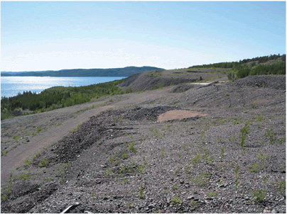
The Beaverlodge site has three tailings management areas, which contain 5.8 million tonnes of tailings and 4.3 million tonnes of uranium tailings disposed of underground - for a total of 10.1 million tonnes of lower-grade uranium mine tailings. In addition to this figure, there are approximately 5.1 million tonnes of waste rock on the site.
The site consists of 73 separate properties that cover approximately 744 hectares. There were 17 different mining areas; 10,161,000 tonnes of ore were recovered that averaged 0.25 percent uranium (0.10 to 0.43 percent ranges).
8.1.1.2 Gunnar and Lorado
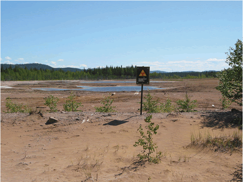
On April 2, 2007, the Government of Canada and the Government of Saskatchewan announced the first phase of the cleanup of closed uranium mine and mill sites in northern Saskatchewan (principally Gunnar and Lorado). Private sector companies that no longer exist operated these facilities from the 1950s until the early 1960s. When the sites were closed, the regulatory framework in place was not sufficient to ensure an appropriate containment and treatment of the waste, which has led to environmental impacts on local soils and lakes. The total cleanup cost, which the governments of Canada and Saskatchewan will share, will be $24.6 million.
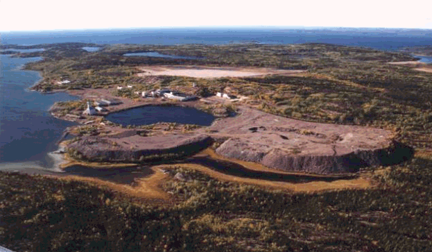
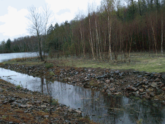
The Gunnar mine site is located on the southern tip of the Crackingstone Peninsula along the North shore of Lake Athabasca, approximately 25 kilometres southwest of Uranium City, Saskatchewan (see Figure 8.3). The Gunnar mine site has been closed since 1964, and has not been adequately decommissioned.
On June 15, 2007, a comprehensive environmental assessment for the Gunnar project began pursuant to the provisions of the Canadian Environmental Assessment Act. The federal authorities responsible for the assessment are the CNSC (responsible for issuing the licence for the project) and Natural Resources Canada (responsible for partially funding the project.) An environmental assessment is also being conducted by the Government of Saskatchewan, in accordance with the terms of the Canada-Saskatchewan Agreement on Environmental Assessment Cooperation.
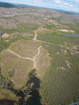
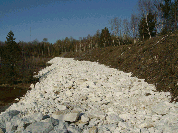
The Lorado Uranium Mining Ltd. mill site is located north of Lake Athabasca in the northwest corner of Saskatchewan, approximately eight kilometres southwest of Uranium City (see Figure 8.2). EnCana West Limited (EWL) had been identified as the owner of the land on which a portion of the unconfined tailings from the Lorado milling operation exists. The remainder of the site is provincial crown land. In 2008, EWL negotiated an agreement with the Saskatchewan government. EWL has paid a significant amount of money in exchange for the government to assume current and future control and responsibility of the site. Work related to the remediation of the Lorado site will require the CNSC licensing and joint regulatory approvals.
8.1.2 Northwest Territories
There are two licensed closed uranium mine and tailings sites in the Northwest Territories: Port Radium Mine and Rayrock Mine.
8.1.2.1 Port Radium
The Port Radium site is located in the Northwest Territories at Echo Bay on the eastern shores of Great Bear Lake, about 265 kilometres east of the Dene community of Déline at the edge of the Artic Circle. Mining at the Port Radium site occurred from 1932 to 1940, from 1942 to 1960 and from 1964 to 1982 - in the last instance, to recover silver. The site covers approximately 12 hectares, and is estimated to contain 1.7 million tons of uranium and silver tailings. The site was partially decommissioned in 1984, according to the standards of the day. In 2006, the federal government reached an agreement with the local community, and completed the remediation of the site in 2007 under a CNSC licence.
Indian and Northern Affairs Canada (INAC) will continue performance and environmental monitoring and reporting under the licence. The following are the results from the sampling of the radiological surface water for 2007:
- < 6 Bq/L for Radium-226
- < 0.1 Bq/L for Lead-210
- < 20 µg/L Uranium
These levels are below the discharge limits specified in the licence conditions, and below the Canadian Water Quality Guidelines and Health Canada's drinking water criteria.
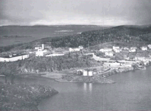
Figure 8.4 (a) - Aerial Photo (1950s) of Port Radium Mine
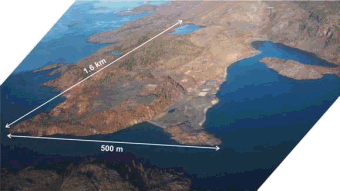
Figure 8.4 (b) - Aerial Photo 2002 of the Port Radium Mine
8.1.2.2 Rayrock
Uranium mining and milling occurred at the Rayrock site from 1957 until 1959, when it was abandoned. Following an environmental assessment and the issuance of an AECB licence (reissued as a CNSC licence in 2001), INAC decommissioned and rehabilitated the Rayrock site (including the capping of the tailings) in 1996. Performance monitoring and reporting of the results has been ongoing since 1996.
INAC sampled surface water for 2007 and reported the following radiological concentrations at the final point of control:
- 0.06 Bq/L for Lead-210
- 0.02 Bq/L for Polonium-210
- 0.09 Bq/L for Radium-226
- 0.01 q/L for Thorium-228
- 0.07 Bq/L for Thorium-230
- 0.01 Bq/L for Thorium-232
- 0.2 Bq/L for Uranium-234
- 0.0038 Bq/L for Uranium-235
- 0.0047 Bq/L for Uranium-238
For the 2007 sampling period, many of the radionuclide concentrations were below detection limits, and in all cases below the Canadian Water Quality Guidelines and Health Canada's drinking water criteria.
8.1.3 Ontario
8.1.3.1 Elliot Lake area
There are 12 inactive uranium mine sites and ten uranium tailings management areas (TMAs) in and around Elliot Lake, Ontario. All of the Elliot Lake uranium mines were brought into production between 1955 and 1958. By 1970, five of the mines had been shutdown; by 1992, most had ceased operations. The last of the Elliot Lake uranium mines to be decommissioned - Stanleigh, Quirke, Panel, Stanrock and Denison mine sites - were essentially complete by the end of 1999. Currently, all of the sites have been substantively decommissioned, with all mine features capped or blocked, all facility structures demolished, and all sites landscaped and re-vegetated.
The uranium ore in the Elliot Lake area is classified as low grade (containing less than 0.1 percent U3O8). It also contains pyrite and uranium decay products such as radium-226. When exposed to oxygen and water, the tailings become acid-generating, and may mobilize contaminants. Most of the Elliot Lake TMAs, therefore, have some degree of effluent treatment system associated with each site. All of the TMAs have been closed, and all construction activities related to the containment structures have been completed. Currently, the mining companies conduct site-specific and regional environmental monitoring programs, operate the effluent treatment plants, and inspect and maintain the sites.
Rio Algom Ltd. is responsible for the Quirke, Panel, Spanish American, Stanleigh, Lacnor, Nordic, Buckles, Pronto and Milliken mine sites, and their associated TMAs, while Denison Mines Inc. is responsible for the Denison, Stanrock and Can-Met mine sites and their TMAs.
Decommissioning of uranium mines and mills is governed by the Uranium Mine and Mills Regulations under the NSCA. Two of the mine sites - Denison and Stanrock - currently have the CNSC uranium mine decommissioning licenses in effect.
In 2004, Rio Algom Ltd. consolidated all of its Elliot Lake mine sites under one the CNSC licence: a waste facility operating licence governed by the Class 1 Nuclear Facility Regulations under the NSCA.
Effluent treatment and environmental monitoring
In Elliot Lake, there is a mixture of both dry and wet covers being used at the TMAs. Four of the TMAs - Lacnor, Nordic, Pronto and Stanrock - are engineered with dry covers, and vegetation has been established over the tailings at all of these sites. Active water treatment is required at all of the dry tailings management areas to correct for acid generation and radium dissolution in the effluent streams, according to the predicted performance for the dry tailings covers. It is expected that water treatment will be required for many more years to come at these sites, as the acid-generating potential of the tailings is slowly exhausted due to surface water infiltration and oxidation of the tailings.
The other TMAs - Quirke, Panel, Stanleigh, Spanish American and Denison - are all water covered, and most require some form of active water treatment. However, the extent of treatment required is greatly reduced over that of the effluents resulting from the dry cover TMAs (the water covers minimize exposure to oxygen and the resulting generation of acid). Many of these sites currently require only minimal treatment, and it is expected that the effluent treatment plants will not be required for the length of time predicted at the dry covers sites.
With respect to environmental monitoring, both of the licensees have each implemented two programs: the TMA Operational Monitoring Program and the Source Area Monitoring Program. The first collects data to track TMA performance, and supports decisions regarding the management and discharge compliance of the TMAs. The second program was developed to monitor the nature and quantities of contaminant releases to the watershed.
In addition to these measures, both Rio Algom Ltd. and Denison Mines Inc. have jointly implemented two watershed-wide programs, referred to as the Serpent River Watershed Monitoring Program (SRWMP) and the In-Basin Monitoring Program.
The SRWMP is designed to evaluate the effects of all mine discharges and water-level changes on the receiving watershed, focusing on water and sediment quality, benthos, fish health and radiation and metal doses to humans and wildlife. The Serpent River watershed is comprised of more than 70 lakes and nine sub-watersheds, which cover an area of 1,376 square kilometres and drain into Lake Huron via the Serpent River.
The In-Basin Monitoring Program is a companion program to the SRWMP that focuses on the risks to biota feeding at the TMAs by monitoring the physical, chemical and ecological conditions at the TMAs, including the tracking of ecological changes. Both programs run in five-year cycles. The first cycle was completed in 1999; the second cycle summary report was completed in 2007.
The Rio Algom Ltd. and Denison Mines Inc. mine sites are licensed by the CNSC for possession, care and maintenance of nuclear substances that are found in the tailings management areas. There are no emissions from the tailings management areas, with the exception of surface water run-off. Tailings management area waters are treated as required by the licensees, prior to release, and meet the discharge limits that are set in each individual licence. After being treated, they discharge into the Serpent River watershed, and are further diluted by the watershed until they ultimately discharge into Lake Huron via the Serpent River. Biological effects monitoring programs have indicated some impairment of the lake's bottom living benthic invertebrate community in the initial receiving water bodies but no significant impairment of the downstream watershed.
These sites will continue to require monitoring and active management until effluents meet discharge criteria without treatment. These sites will then require some form of ongoing (permanent) care and maintenance.
Community involvement
With respect to community involvement, the mining companies maintain a public presence in Elliot Lake, offering
facility tours, a Web site and a public information program that keeps the community and city council updated with
respect to on-going activities at the sites. The Serpent River Region Environmental Committee (SRECC), a local
environmental committee, attends facility inspections along with the CNSC and the Joint Regulatory Group (who
represent the other federal and provincial regulators that have an interest in the Elliot Lake operations). Over the
last several years, the CNSC personnel have conducted outreach activities in Elliot Lake, hosted open houses and
attended a public forum hosted by the SRREC.
8.1.3.2 Agnew Lake
The Agnew Lake Mine, located about 25 kilometres northwest of Nairn Centre, Ontario, ceased operation in 1983. The uranium mine site was decommissioned and monitored by Kerr Addison Mines from 1983 until 1988. The site was then turned over to the Province of Ontario in the early 1990s. The Ministry of Northern Development and Mines holds a CNSC Waste Nuclear Substance Licence for the Agnew Lake idle tailings site. The CNSC personnel conduct a compliance inspection of the Agnew Lake Mine once every three years. The Ministry of Northern Development and Mines reported the following 2007 sampling results for the radiological surface water at the final point of control:
- Radium-226: <0.01 Bq/L
- Lead-210: 0.1 Bq/L
- Polonium-210: <0.01 Bq/L
- Thorium-230: <0.01 Bq/L
These levels are below the Ontario Provincial Water Quality Objectives (PWQO).
8.1.3.3 Bancroft area
Uranium tailing management sites also exist at the Madawaska, Dyno and Bicroft mines in the area surrounding Bancroft, Ontario. The Madawaska Mine has been inactive since 1983, while operations at the Dyno and Bicroft sites ceased in the early 1960s.
8.1.3.3.1 Dyno Idle Mine Site
The Dyno Idle Mine property is located at Farrel Lake, about 30 kilometres southwest of Bancroft, Ontario. The mill circuit at Dyno operated between April 1958 and April 1960. The property consists of an abandoned, sealed underground uranium mine; a mill, which has been largely demolished; a tailings area; two dams; and various roadways. The site is managed and monitored by EnCana Corporation, which holds a CNSC Waste Nuclear Substance Licence for the Dyno Idle Mine site.
During the sampling period of 2007, EnCana West Ltd. provided the following results for the radiological surface water at the final point of control:
- Concentrations of uranium were measured to be 0.00078 mg/L in the spring of 2007, and 0.00067 mg/L in the fall of 2007. Both of these samples are well below the interim PWQO for uranium (0.005 mg/L).
- Concentrations of radium-226 in samples collected in the spring and fall were 0.1 Bq/L and 0.4 Bq/L, respectively. Concentrations of radium-226 are lower than the PWQO (0.6 Bq/L).
- Concentrations of thorium-230, measured in the spring and fall, were below detection limit (<0.01 Bq/L).
- Concentrations of polonium-210, measured in the spring and fall, were both at the detection level (0.01 Bq/L).
- Concentrations of lead-210, measured in the spring and fall, were below the respective detection limits (<0.1 Bq/L and <0.02 Bq/L).
8.1.3.3.2 Madawaska Mine Site
The Madawaska Mine property is located six kilometres southwest of the town of Bancroft, Ontario on Highway 28. Initial mining and milling operations at Madawaska (Faraday) Mine ran from 1957 until 1964, and again from 1976 to 1982. Reclamation activities were carried out from 1983 to 1992. The Madawaska site has a decommissioning approval licence from the AECB (now the CNSC). Madawaska Mines Limited holds the licence, and the site is monitored and managed as part of a joint venture by EnCana West Limited.
During the sampling period of 2007, EnCana West Ltd. provided the following results for the radiological surface water at the final point of control:
- During the spring 2007 sampling event, the concentration of uranium was measured at 0.006 mg/L, slightly exceeding the PWQO (0.005 mg/L). During the fall 2007 sampling event, the concentration of uranium was 0.05 mg/L, also greater than the PWQO. These uranium concentrations are consistent with the data collected from 1989 to 2006.
- Concentrations of radium-226, measured during the spring and fall sampling events, were 0.01 Bq/L and 0.09 Bq/L, respectively, and are below the PWQO (0.6 Bq/L).
- During the 2007 sampling events, concentrations of thorium-230, polonium-210 and lead-210 were below detection limits (<0.01 Bq/L, <0.01 Bq/L and <0.01 Bq/L, respectively, for the spring samples, and 0.01 Bq/L, <0.005 Bq/L and <0.02 Bq/L, respectively, for the fall samples).
8.1.3.3.3 Bicroft Tailings Storage Facility
The uranium tailings stored in the Bicroft Tailing Storage Facility resulted from processing low-grade uranium ore at the Bicroft mine from 1956 to 1962. Remediation work has included vegetation of exposed tailing in 1980, and upgrading of dams in 1990 and 1997. In 2005, the Barrick Gold Corporation (Barrick) was issued a Waste Nuclear Substance Licence for the Bicroft Mine. The effluents discharge results generally meet the PWQOs results, with a few exceptions. As part of its licence application, therefore, Barrick conducted a Screening Level Human Health and Ecological Risk Assessment (SLHHERA) to demonstrate that there is no unreasonable risk to the health, safety and the environment, and to support a five-year surface water-sampling program. The most recent sampling data provided by Barrick is from 2005. The results for the radiological surface water at the final point of control are 0.87 Bq/L for radium-226 and 35 ppb for uranium.
8.2 Contaminated lands
8.2.1 Contaminated land under institutional control
8.2.1.1 Consolidated cells
Three historic aboveground waste consolidation cells are being managed under institutional controls. These engineered consolidation cells are located in Fort McMurray (Alberta), Fort Smith (Northwest Territories) and the Passmore in Toronto (Ontario). The CNSC has exempted these cells from a requirement for licensing until 2016.
Historic waste from a cell in Tulita (Northwest Territories) has been repackaged, and the repackaged materials are currently being managed at the site of the old cell under a CNSC licence. The LLRWMO is currently pursuing a plan that would see these wastes transported to a disposal facility by October 2008.
A buried cell of uranium-contaminated material was established in Peterborough (Ontario) in 2004. It is currently being managed under institutional controls, and has been temporarily exempted by the CNSC from the requirement for licensing.
An aboveground contaminated soils consolidation cell is located on Lakeshore Road in Toronto. It is being managed under a CNSC licence.
The materials in the Peterborough and the Lakeshore Road consolidations cells do not meet the federal government's definition of historic waste. They are contaminated materials being managed by a third party.
8.2.1.2 Fort McMurray
The Lower Town site and Waterways sites in Fort McMurray, Alberta (located at the junction of the Athabasca and Clearwater rivers) were the southernmost terminals of the Northern Transportation Route (Ntr). It was at these sites that the uranium ore was offloaded from water barges and transferred to trains for transport to Port Hope, Ontario for processing. The contaminated soils associated with these sites were cleaned up during the period of 1992 to 2002, and consolidated into a purpose specific engineered containment cell constructed adjacent to the municipality's landfill site. The cell, which contains approximately 42,500 cubic metres of contaminated soils, is fenced and monitored by the LLRWMO. The cell has not yet been licensed by the CNSC, and a formal licence application for the cell is pending the federal government's review of its waste management strategy.
8.2.1.3 Fort Smith
The Town of Fort Smith is located on the west bank of the Slave River, just north of the border between Alberta and the Northwest Territories. Fort Smith was a staging point along the Ntr where cargo (including the uranium ore from the Port Radium Mine) was portaged around four sets of rapids on the Slave River. In 1998 and 2001, contaminated soil and building material, discovered on private and public lands in the town, were cleaned up and transferred to a temporary storage cell constructed near the town's landfill site. The covered cell, which contains approximately 350 cubic metres of contaminated soils, is signed and fenced, and monitored by the LLRMWO. The temporary storage cell has not yet been licensed by the CNSC, and a formal licence application for the mound is pending the federal government's review of its waste management strategy.
8.2.1.4 Passmore Storage Cell
The Passmore Storage Cell is located in the Malvern Community of Toronto, Ontario (northeast part of Toronto). Malvern is a planned community that involves the redevelopment of agricultural lands into residential, light industrial and commercial uses. One of the redeveloped farms was used in the late 1940s and early 1950s as the site of a radium recovery operation. During the course of redevelopment activities, residual pieces of radium-bearing materials and contaminated soils, originating from the recovery operation, were deposited on residential lots. In 1993, the Malvern Remedial Project was established as a joint Canada-Ontario initiative to address the radium contamination in the Malvern Community.
Under the management of the LLRMWO, a cleanup program was conducted, which involved the excavation and transportation of the contaminated soil to the Passmore Avenue site, where the soil was sorted into licensable, mildly contaminated and clean fractions. The licensable material (approximately 50 cubic metres) was transferred off site to an existing licensed facility. The mildly contaminated fraction was consolidated into a purpose specific engineered containment cell constructed on the Passmore Avenue site. The cell, which contains approximately 10,000 cubic metres of contaminated soils, is fenced and monitored by the LLRWMO. The cell is under institutional control, and measures for placing it under regulatory control are being considered.
8.2.1.5 Tulita
The hamlet of Tulita is located in the Northwest Territories on the east bank of the Mackenzie River, just south (upstream) of the Great Bear River confluence. (The Great Bear River is the water link between Great Bear Lake and the Mackenzie River.) Tulita was a staging point along the Ntr where the uranium ore from the Port Radium mine was transferred from small-river to large-river barges. Most cargo transfers occurred directly from barge to barge; however, on one occasion, the bags of ore were off-loaded from the barges and temporarily stored over the winter on private properties in the community. In 1992, 1999 and 2001, the LLRMWO conducted cleanups of those private properties, and consolidated the contaminated soils into a temporary storage cell, constructed on hamlet-owned land near the airport. The covered cell, which contained approximately 867 cubic metres of contaminated soils, was signed and fenced, and is monitored by the LLRMWO.
In 2007, the material in the cell was repackaged for transportation to the Port Radium Mine site for incorporation into the tailings basin before it was capped. The logistics proved too difficult, however, and the repackaged material has been stored at the site of the original cell, under a CNSC licence, until an alternative storage solution is determined. The LLRWMO is currently pursuing a plan that would see these wastes transported to a disposal facility by October 2008.
8.2.1.6 Peterborough
An empty field that used to house an assay company in the 1960s was found to be contaminated with uranium ore. A clean-up took place in 2004, and the resulting 300 cubic metres of material were placed in a lined cell under the parking lot of a new warehouse. The cell is marked on all property plans, and is being managed under institutional controls.
8.2.1.7 Lakeshore Road
In 1999, radium contaminated soils were consolidated into an aboveground cell at the Lakeshore Road property in Toronto. The property was the site of a factory that produced weapons sights and other radio-luminescent devices. The cell contains approximately 2,000 cubic metres of mildly contaminated soil. In January 1, 2006, the Toronto Regional Conservation Authority (trCA) was issued a CNSC Waste Nuclear Substance Licence for the Lakeshore Road Storage Mound.
8.2.1.8 Deloro
The Deloro Mine Site Cleanup Project is an initiative of the Ontario Ministry of the Environment (OMOE) designed to clean up the abandoned mining, refining and manufacturing site located at Deloro, Ontario. The OMOE assumed responsibility for this site in 1979, when the site owner failed to comply with ministry orders to control the contamination that was leaving the site.
Although not a uranium mine, the 202-hectare property was the location of mining, refining and manufacturing activities for more than 100 years. The site is located along the banks of the Moira River, beside the eastern boundary of the Village of Deloro (population of 180).
The environmental legacy at the Deloro Mine Site includes contamination of soils, sediments, groundwater and surface water, with arsenic, cobalt, copper, nickel and low-level radioactive waste. Only two to six percent of the waste material on the Deloro Mine Site consists of low-level radioactive wastes. Arsenic remains the contaminant of main concern.
The overall objective of the Deloro Mine Site Cleanup Project is to remediate the abandoned mining and industrial complex by isolating and containing the wastes and engineering the site to protect people and the environment. The draft cleanup plan is intended to isolate and contain the various contaminants, totalling about 650,000 cubic metres in volume, within the boundaries of the Deloro Mine Site. None of the existing waste materials will be taken off-site.
In general terms, the draft clean-up plan proposes to:
- excavate and consolidate the most contaminated materials under engineered covers made of clay, sand, topsoil, loam and clay liner,
- use engineered clay caps to cover the less contaminated materials,
- manage surface and groundwater to minimize contact with the wastes, and
- treat contaminated surface water leaving the site.
The cleanup will focus on four main areas where different industrial, mining and manufacturing activities took place: industrial area, tailings area, Young's Creek and mine area. The project will be implemented in three phases. The first phase includes an environmental assessment and the CNSC decisions related to the assessment, a regulatory technical review of the project and licensing. Subsequent phases will include the cleanup and consolidation of materials at the site, followed by a phase of long-term inspection, monitoring and maintenance.
Based on the project description and the letter of intent, a screening level environmental assessment is required, pursuant to the CEA Act, before the CNSC can consider providing the OMOE with an authorization (through licensing) to conduct remedial work at the Deloro Mine Site. The CNSC delegated responsibility to conduct the technical studies and associated public consultation to the OMOE as the proponent. The CNSC approved the environmental assessment screening guidelines at a public hearing in 2003.
From the project schedule provided by the OMOE, the CNSC personnel anticipate presenting the environmental assessment screening report at a CNSC hearing in February 2009 if no further revisions to the resubmitted environmental assessment study report are required. Based on the environmental assessment schedule, and in accordance with the CEA Act, the authorities responsible for the project (the CNSC and Fisheries and Oceans Canada) are expected to make decisions on the project in 2010.
With respect to public consultation, the OMOE conducts public meetings and open houses, has a project-specific area on the OMOE Web site, and meets regularly with three liaison committees to keep them informed and to gather input and comments.
8.2.2 Historic contaminated lands
8.2.2.1 Fort Fitzgerald
From the early 1930s to the 1950s, uranium ore was transported by the Ntr from Port Radium on Great Bear Lake, Northwest Territories to the railhead at Waterways (now Fort McMurray, Alberta). Contaminated sites at Fort Fitzgerald exist within 100 metres of the river's edge. As part of the Ntr, the sites were used as docks and boat launches. Radiological surveys were conducted in 2004, 2005 and 2006. Data from all the surveys were summarized in 2006, and the material volume was updated to approximately 10,000 cubic metres.
8.2.2.2 Sahtu Region
The Sahtu Region contaminated sites exist in isolated locations along the Great Bear River, and at one remote end of Great Bear Lake in the Northwest Territories. Clean-up activities conducted by the LLRWMO at one site removed the highest-grade material, and brought readings down to below background levels. In 2003, the ten sites along the Great Bear River were characterized; only two sites require the care of institutional controls by the Sahtu Land and Water Board and INAC. The results of the characterization were provided to the communities of Déline and Tulita. Further characterization work is planned for 2008 to identify the volume of contaminated soil at the site.
The landowners and administrators of these Northwest Territories sites have been informed of the radiological contamination, and are aware of the requirement for restrictions on construction activities at the sites. They also know about the need to contact the CNSC if construction activities were ever to occur.
8.2.2.3 Toronto, Ontario
Toronto area contaminated sites include radium contaminated soils on lands owned by the Province of Ontario, the Toronto Regional Conservation Authority (trCA), Ontario Realty Corporation (ORC) and private landowners. Contaminated sites also included radium contamination fixed to structural elements in privately owned buildings.
The contaminated soils are generally covered, or occur in areas of low use (primarily open space). One former scrap metal yard is fenced and is undergoing characterization by ORC for both radiological and non-radiological contaminants. The contaminated material in buildings is isolated behind double walls and ceilings.
The owners of the properties are aware of these control measures, and the tenants are restricted from construction activities that would compromise these safeguards. The owners are also aware of the process that requires the CNSC to be contacted and given the opportunity to assess any proposed construction or land-use changes. The CNSC maintains contact with the owners/managers of the sites through visits and phone conversations, and conducts site visits once every three years.
8.2.2.4 Port Hope Area Initiative for the long-term management of historic low-level radioactive wastes
On March 29, 2001, an agreement was signed between the Government of Canada (represented by the Minister of Natural Resources) and the communities of Port Hope, Hope Township and Clarington for the construction of long-term waste management facilities for historic low-level radioactive wastes and for the cleanup of contaminated sites in the Port Hope area. The wastes consist of about two million cubic metres of LLW and contaminated soils, containing radium-226, uranium and arsenic as the primary contaminants.
With this agreement, the Government of Canada began an initiative to evaluate and implement a long-term solution for the management of the wastes from the Port Hope area sites. The initiative has been divided into two projects that accord with municipal boundaries. The Port Hope Project entails the cleanup and long-term management of wastes from various contaminated sites in the Municipality of Port Hope - formerly the Town of Port Hope and Hope Township. The Port Granby Project involves the implementation of a long-term management approach for radioactive wastes at the existing Port Granby Waste Management Facility in the Municipality of Clarington.
Single purpose-built facilities are being planned to manage the wastes from each cleanup project: the Port Hope Long-Term Waste Management Facility (PHLTWMF) and the Port Granby Long-Term Waste Management Facility (PGLTWMF). The PHLTWMF, with an estimated design capacity of 1.8 million cubic metres, is planned to accept a variety of wastes from the area. These include wastes from the major unlicensed sites in the Municipality of Port Hope such as the Alexander Street ravine, the waterworks, the viaducts area, the Mill Street south site, the landfill and the harbour. Other wastes, such as contaminated roadways and soils from private properties, will also to be included, along with wastes from Cameco's Welcome Waste Management Facility, and specified historic wastes from the Cameco conversion facility. Wastes from consolidation sites and temporary storage sites within the community that are being temporarily managed by the LLRWMO will also be included, along with non-radiologically contaminated industrial wastes, as requested by the municipality and provided for in the agreement.
The PHLTWMF is planned for an expanded site at the existing Welcome Waste Management Facility located in the Municipality of Port Hope, which currently contains an estimated 500,000 cubic metres of low-level wastes and contaminated soils. An environmental assessment process has been completed for this project. The implementation phase of the project is expected to last for seven years, pending successful completion of the licensing process, which will be followed by long-term monitoring and surveillance.
The PGLTWMF, with an estimated design capacity of 600,000 cubic metres, is being planned to accept wastes only from the existing Port Granby Waste Management Facility, which is currently owned and operated by Cameco, and located in the Municipality of Clarington. The site considered for these wastes is immediately northwest of the existing facility and away from the Lake Ontario shoreline. The implementation phase of this project is expected to last for six years, once the environmental assessment and licensing processes are concluded. Long-term monitoring and surveillance will follow this phase.
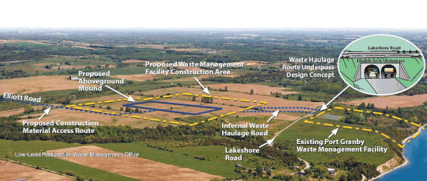
Low-Level Radioactive Waste Management Office
Proposed Construction Material Access Route
Elliott Road
Proposed Aboveground Mound
Proposed Waste Management Facility Construction Area
Waste Haulage Route Underpass Design Concept
Lakeshore Road
Double Arch Underpass
Existing Port Granby Waste Management Facility
Lakeshore Road
Internal Waste Haulage Road
8.2.2.5 Port Hope contaminated sites
A number of contaminated sites have been identified in the Municipality of Port Hope. Some of these sites are known as major unlicensed sites, others are known as small scale sites, and there are also some licensed and unlicensed temporary storage and consolidation sites. Although many of these sites are not currently licensed by the CNSC, the CNSC is aware of them and is comfortable with how they are being managed. The sites are safe for casual access, pending implementation of the project known as the Port Hope Area Initiative, which will remediate them once the long-term waste management facilities for the project have been developed.
The major sites are generally well known by the community and municipality, and will not be further developed until the historic waste deposits can be removed to an appropriate storage facility. Small pockets of contaminated soils, however, also exist on roadways and municipal road allowances, and on municipal, private and commercial properties. These sites are known collectively as small-scale sites.
The development of these sites (which may include common activities such as road repair, infrastructure repair and maintenance, property re-grading/landscaping, and private or commercial property development or renovation) is accommodated under the Construction Monitoring Program, an administrative program between the LLRWMO and the Municipality of Port Hope.
The municipality forwards projects that require municipal building permits to the LLRWMO for review and action. This action often results in a radiological monitoring of excavated materials in construction areas. If contaminated soils that need to be removed are identified, they are accepted at the Pine Street Extension Temporary Storage Site, a CNSC licensed storage facility. The project may then continue as planned. The LLRWMO also accepts applications to the program directly from residents for projects that do not require building permits.
Larger projects, which may negatively impact upon the LLRWMO's ability to receive wastes at its temporary storage site (it currently has a receiving capacity of approximately 5,200 cubic metres), are accommodated through the construction of small purpose built consolidation or storage sites. In the long-term, through the PHAI, the objective is to consolidate this material within the purpose built Port Hope Long-Term Waste Management Facility.
Page details
- Date modified: